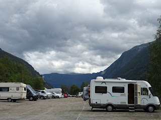
Looking back the way we came up
Our park was at about 1200m. That lump to the right is Gaustatoppen,at 1883m
There were some nice views of course
There are baches/huts sprinkled about the area. The Norse are a hardy lot
We topped up the radiator and oil, and moved on over one more stretch of bends. Gaustatoppen's claim to fame is two-fold. It was an early ski destination from the 19th C (First climbed in 1810 from memory.) Then in the 20th C someone had the idea to build a lift from the plateau to the top - through the mountain! The cold war was just starting so the military took over the project and built a horizontal tunnel then a railway that rises at 39 deg to a communications facility on top (though not at the peak). The walk up/down is very popular and we saw folks starting up as we drove past.
Can you see the comms tower through the cloud? The hut is at the carpark at the bottom of the railway. This is where our satnav had been programmed for the previous night.
You can see the tunnel networks here. The cross ones at the top are not open to tourists so you have to walk the final little bit. (Click to enlarge the photo.)
The tunnels were demilitarised in the 1990s as the Cold War spluttered out. The technology was redundant anyway so now it is more important for cellular networks. You can walk to the real peak but it's along a razorback ridge so not my thing.
Norwegians love digging holes in mountains. Road, rail, h-e: it all goes through mountains. This is the horizontal section.
A fairly simple railway.
And this is the vertical section. Well, 39 deg.
A view from the top station. You can see the walking trail bottom centre.
It's a pretty flaky sort of rock so there are massive scree slides and boulder fields.
There's Reggie way down there. (~800m vertically.)
J stepping off the edge of the world
Modelling for Norway's version of Rio's Christ the Redeemer
Looking down the tunnel. Operators have to prove they can climb the 3000+ steps once a year.
There's some fit buggers heading off on their walk to the top.
Next stop involved a switch-back road down the mountain. Not quite so hard on Reggie. Rjukan was at the bottom and we had some things to see there. The town was purpose-built for the hydro scheme, kind of like Cadbury's in the UK. During the winter it never sees the sun, so the hydro company installed mirrors to shine on the town square!
Gaustatoppen has a very distinctive shape from the side. (The switch-back had no convenient stopping points for photographs.)
Rjukan
The newer power station behind some of the lovely wooden houses. The water is fed through tunnels from lakes up the top
Imposing architecture to be a mark of pride for the nation
The mirrors reflecting sunlight into the town square.
Our lunch spot and our park for the night - the bottom of the Krossobanen.
Krossobanen cablecar from the top.
Gaustatoppen from the front, with Rjukan below. We stood up there yesterday. (Make a mental note of the bare patch on the top left here.)
Looking for a tree to hug
The view from the bare patch previously mentioned.
J looking for trolls. Doesn't she know they're all online now?
A massive ants' nest. Not to be mistaken for a massive ant's nest. I guess the pine needles keep the nest warm in the cold and snowy weather.
The weather closed in again, and just after we got into the MH, it bucketed down once more. That comes from ribbing my workmates about the lousy weather in Britain.
Gaustatoppen
Tomorrow's goal. Vemork power station. Our plan is to make our way down the slope, cross the gorge, break into the plant, blow it up then ski to Sweden. (It'd never work.)


No comments:
Post a Comment